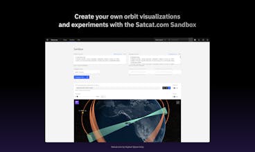
With over 60,000 objects in our database and up to four years of space data, Satcat.com is designed to help you track, research, and experiment with satellites and their orbits.
Hi everyone! đŸ‘‹ I'm Hyun, VP of Product at Kayhan Space. We're a SaaS company striving to create top-notch software experiences for the space industry. Our software is currently being used by leading satellite operators.
As a company, we aim to offer something for everyone. While there's a wealth of data available from sources like space-track.org and "GCAT" from Jonathan McDowell's website, and numerous tools, what's missing is a unified platform. The industry lacks a space-related tool with modern user experience accessible to all.
Today, we're excited to announce the launch of Satcat. Whether you're a satellite operator, astronomer, or simply interested in space, there's something for you to explore on Satcat!
Here's what you can do with Satcat.com:
- Track satellites like the International Space Station in real-time and get forecasts on when they'll be visible from your location.
- View a 3D globe of active satellites.
- Access up to 4 years of historical TLEs and orbital elements data.
- Load your own TLEs and visualize your own orbits.
- Search satellites by owner, country of origin, launch date, decay date, orbital elements, and more.
And did I mention it's free?
This is just our first release, and we're thrilled to share it with you and see it grow.
Check it out for free at https://www.satcat.com.
---
Please check out these YouTube videos to max out Satcat's utility!
How to use the basic search
How to use the advanced search
How to use the Sandbox
Congratulations on the launch, Hyun and the team! Satcat's real-time satellite tracking sounds impressive. How do you handle the updates for decayed or newly launched satellites in such a large database?
@kirill_markin Thank you so much Kirill! So we currently update our trajectory (in TLE format) database twice a day. Separately, we update our satellite catalog twice a day.
The trajectory database obviously expands more and more as time goes on; so we time-bucket them in the database by year and month.
Thank you for the interest and happy searching!
@fabdurso Thank you Fabrizio! So a lot of the data comes from the US Space Force via space-track.org in a format called TLE / 3LEs (Two or Three Line Elements). It's literally a 3 lined string that has "orbital parameters" in them; I.e., what was the physical state of an object in a given time? Then we historically catalog that (that's how you get the time-based plots) and for the globe, we "propagate" them. I.e., using a physics simulator called SGP4, it forward/backward projects the trajectory of a given satellite.
Fun fact: TLEs have about a ~1km+ error distance; not too bad when viewing dots on a 30" screen, but not very good when you want to coordinate two separate satellite to avoid a collision!
Satcat
ozma.io
Satcat
OutyPlay
Satcat
OutyPlay
Satcat