Hi ProductHunt community! First of all, huge thanks to @kwdinc for hunting us!
PeakVisor is an augmented reality app which answers the most common question in the mountains. What that mountain is?! Probably, it will be able to answer other questions soon ;-)
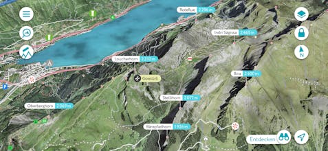
Here’s how it works:
1. You point the phone camera at mountains
2. PeakVisor labels all the peaks
3. PeakVisor renders semi-transparent terrain model, so you could adjust & calibrate phone sensors
That's it!
Here are some details about our PeakVisor journey (a quick read): https://medium.com/@denivipmedia...
We’d love to hear your comments and feedback!
Thank you!
Looks nice! It would be great to show some other information as well. Obviously, mountain huts :)
Maybe major attractions. Have you thought about that? Any plans?
@flighthack We plan to add mountain huts in the next release (a couple of weeks from now). Didn't think about attractions, but I agree that it might be interesting to see some special things. For example, here in Europe we often have castles in the mountains and it might be useful to see them as well.
@pbriod Please send me an email on denis@routes.tips is you'd like to be one of the first to get the Android version. It should be ready in several weeks.


PeakVisor
Prelaunch.com
PeakVisor
PeakVisor
Prelaunch.com
Flystein
PeakVisor
Monito
Monito
PeakVisor
PeakVisor
PeakVisor
Monito