Flypix AI

Flypix AI

AI Enabled Geospatial Solutions

53 followers

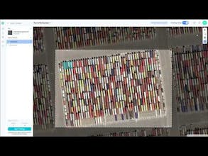
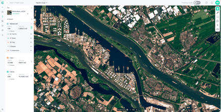
Create AI use cases with Aerial and Satellite Imagery: detect objects and segment land on earth observation data. NO knowledge about AI or Machine Learning is required.
Flypix gallery image
Free Options
Launch Team

What do you think? …

Ivan Tankoyeu
The tool allows users to create AI models to detect any object on satellite or drone images. It works pretty simply: users just show some examples of the objects on the image they want to detect (trees, cars, trash, solar panels, etc.).
Dexter Donnelly
I love how easy it is to use this tool to detect specific objects in images. The ability to identify anything from trash to solar panels with a few examples is a game-changer for analysis