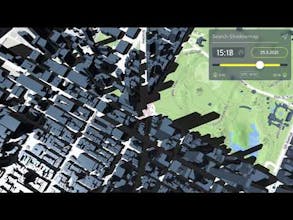
Given the impact the Sun ☀️ has on all our lives, a tool to predict its availability is surprisingly missing – Shadowmap is here to change that. It visualizes sunlight and solar shadows based on 3D data in a worldwide interactive maps app.
Aloha Product Hunt ☀️ and thank you @__tosh for hunting us. It’s an honor 🙌
I’m Georg, founder of Shadowmap and there is so much to say about all that happened along the way to this day! I came up with the idea exactly 8.5 years ago, during a dark and cold winter in Vienna. Streets in the city center are narrow, the buildings are tall and the Sun sits low in the sky. The perfect recipe for a solid winter depression 🤷♂️
For two consecutive weeks I could not see the Sun in the sky and given how busy I was back then, I wanted to at least spend my lunch break in a sunny spot nearby. The 3D data representing shadow occluders should be available – but to my surprise, there was no app making use of it. Years and a few startups later there was still no solution and I finally decided to tackle the problem.
Shadowmap has been in the works for two years now – including a public beta phase kicking off last October – and it is, at last, time for it to see the light of the day! Pun intended!
The process was challenging
Creating a web application that is on the one hand capable of processing large amounts of data while on the other hand performing real-time 3D visualization brought some obstacles with it. Plus, I wanted Shadowmap to be intuitive and familiar to use.
It has been rewarding though
Right from the beginning, conversations with friends brought up new ideas and different use cases: Friends of mine who are into photography immediately saw the potential of having buildings, terrain and the precise Sun’s position integrated into a 3D maps app. Perfect for outdoor and architectural photography – or other shots where one wants to get the lighting perfectly right. To give an example, we recently had our first major customer request, needing advice for an upcoming film shooting in a foreign country: Shadowmap visualizations helped them to choose the right season, hence, Sun position, for their big trip. All of this obviously reaches into territories of cinematographers, directors and drone pilots as well.
But there is more
I got feedback from people who used it to find bright apartments in Vienna (which is where we had 3D buildings first) or others who wanted to buy land in the countryside (@dvassallo 🤫). We also got requests bei municipalities to visualize reflections by solar panels, tourism offices to plan the Sun for winter hiking routes and even a solar car manufacturer, who wants to integrate it into their infotainment system. And we are proud to announce that there will be a real estate pilot project this June. I love this versatility of application and it confirms a phrase I like to use: The Sun is a prerequisite for life on Earth, it affects everything here and Shadowmap is the tool to understand it.
I’m grateful to get the chance to present Shadowmap to you, people of Product Hunt! 😊 I can’t wait to get your feedback, your inspirations, your questions and your plans on how you’ll use it. I’m grateful for the people who helped me along the way with their feedback (@andreasklinger, @__tosh and @levelsio to name a few), @helge, who provided advice and necessary data from the beginning, and especially @simonmulser who started to actively shape Shadowmap with me last summer. He is my future Co-Founder and I can’t ask for a better one. Also for the Austrian Wirtschaftsservice (aws) and its public grant that funded the creation of our first prototype. Further thanks go out to all the people behind open data initiatives we heavily rely on, particularly OpenStreetMap and all open source projects we use, especially Three.js!
Today is the public global launch and with this we also introduce
🌆 Worldwide buildings
⭐️ Shadowmap Pro
While Shadowmap will always be free in its core functionality, Shadowmap Pro is our SaaS for professionals, primarily creatives. Right from the start it offers full camera and date freedom and there is a list of features to be added in the next weeks and months, like simulation of focal lengths, 1st person perspective, placement of custom 3D objects and even a Moon visualization. These features were requested by current users – we will keep listening to you.
Product Hunt Launch Offer
To celebrate, we are giving 50% off of the first 100 Shadowmap Pro subscriptions. That is $99 per year for as long as you’re in. You don’t need a code. Just go to app.shadowmap.org and proceed through the “Shadowmap Pro” button. Of course, there’s a trial period (10 days) so you can try everything out in peace.
That’s it! Thanks for reading and using Shadowmap 🙏
May the ☀️ shine upon you, much love,
Georg
Congratulations, this is so interesting, just to see. I live in India where we don't have to look for Sunny places, do you have a use case for people like me?
@rashjbp I assume there is an abundance of Sun where you live 😊 The cool thing about Shadowmap is that the same way it helps you find the Sun, it helps you find some shade. FYI: iea.org estimates that by 2050 cooling will be the major energy demand in buildings. So it makes sense to incorporate solar radiation into building structures and Shadowmap helps with this! Shadowmap: Helping Humans find some Shade (as well) 😉
@molzer This is cool and actually the truth!! We do look for shades so often :) And the second one is true too, people are going to need maps for building planning, good though, good product :)
Oh wow, this is incredible! This will be super helpful for my work trying to propose a method for quantifying sidewalk shade as a way to help cities plan for heat waves and equitable distribution of shade throughout a city. I guess I'm taking sort of the opposite angle -- looking for shade rather than looking for sun :) This seems like a very useful tool for people working for urban resilience and disaster planning. Congrats on seeing your vision through!
@kim_perez1 This sounds very interesting. Remind me of a story I once read about how streets/avenues in NYC were laid out so that for noon they were the brightest (?) on an average day?
We're also getting regular requests having route planning on either sun or shade, depending on temperature. Please write me if we can help you somehow!
@simonmulser Thanks Simon! I wanted to capture shade from buildings and trees along designated walking routes in my city. I created 3D models in ArcGIS Pro, and used LiDAR data to get that third dimension, but then I had to manually size, shape and place every single tree -- that was painstaking. Do you guys have any plans to add trees? I would imagine that might be challenging on a global scale. I compared my models to field tests, and I had to do a LOT of correcting, to get the trees right. :) For what it's worth, here's a link to what I did, in case you find it useful: https://dash.harvard.edu/handle/....
@molzer Thanks Georg! That's interesting about NYC. I'm from Los Angeles, California, and we definitely have the opposite problem. I signed up for your mailing list and am excited to watch where you take Shadowmap
@simonmulser@kim_perez1 Wow that sounds like significant effort! We had a first try with trees (200k in Vienna, available via open meta data) – and they'll come back in the next months. The related meta data is pretty cool and offers species, stem diameter, height, crown diameter, etc. … so really perfect for a pretty good approximation of reality. TBO, we don't know how the situation looks outside of Vienna, I assume some cities provide similar open data but we'll need to do research on it!
This is such a unique way to visualize sunlight! Shadowmap could be a fantastic candidate for VentureStaking—letting early fans help fund new features while securing an option to invest later.
Shadowmap
Helpdesk by LabiDesk
Shadowmap
Shadowmap
Troopr
Shadowmap
Troopr
Shadowmap
Shadowmap
Shadowmap
Shadowmap