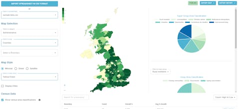
A super simple tool to visualise your customer density across UK geographic boundaries such as counties and regions. Just upload a spreadsheet of postal codes and then export your heat maps as images or generate reports.
Hello there!
I'm James, the founder of Postcodeheatmap, the super simple tool for creating good looking map visualisations from spreadsheets.
I launched this product properly back in October of last year and have since acquired over 50 paying customers, each of whom I am super appreciative of.
Building Postcodeheatmap has been such a great experience, both from an engineering perspective as well as learning from my customers about how to make this product the best it can be.
It is currently aimed at businesses and individuals who have a customer base in the United Kingdom and allows for creating heatmaps (or choropleth maps) based on postal code. This can be useful for visualising things like sales and deliveries across geographic boundaries, such as counties, cities, regions and more. You can also generate reports based on the data that has been aggregated.
If anyone in the Product Hunt community finds this tool interesting then go ahead and give it a try, it's free to play around with. And if you really like it, I have included a 25% discount coupon code.
If you have any questions, then feel free to ask!


Zipcode Heat Map