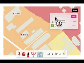
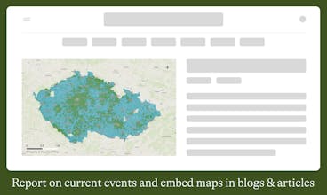
Felt makes it easy for anyone to create and share maps that tell a story — from campsite directions to shifts in climate. For the dozens of industries that rely on maps to get work done, Felt is the first user-friendly, collaborative tool built for teamwork.
Introducing Felt 1.0 — a new suite of tools for organizations to stay aligned with maps. Felt’s new pro features include Team accounts, Team Libraries and a vector rendering engine that will make your data shine. Create a team today!
Hello Product Hunt!
For the last year, I’ve seen how many people around the world rely on maps to do their jobs. After we introduced the beta version of Felt, I was excited to see maps that folks create to make and impact and build community. From sketching out site plans, to coordinating disaster responses and understanding the changing climate, Felt users always left me in awe.
Since starting Felt, I’ve always considered it a tool for teams, but the team and I needed some time to understand our users better to deliver on the promise of a truly collaborative mapping tool.
That’s why I’m excited to share a huge milestone with you: Felt is finally out of beta and we’re doubling down on collaborative features.
With Felt 1.0 comes a whole new suite of tools for sophisticated groups and organizations, such as Teams, Team Libraries, and new features for professionals.
Our biggest new feature, Teams, lets you define a team, and assign editing or viewing permissions to each member. You can move maps between your personal drafts and the shared team space, create folders to organize your team's maps, and join and collaborate across multiple teams.
In addition to Teams, we're also launching a broad set of new features for professionals, including a new rendering engine, a new list view, and more. We're offering these features for free for the first year to learn how people use them and to ensure our pricing matches people's needs.
Our plan has always been to offer a free tier of Felt for personal use alongside paid tiers for professional teams. Starting in 2024, Teams and related features will be available only to paying customers.
Join the hundreds of map makers in the Felt community and create a team today!
If you have any questions about the product, our recent updates, or design process, share them below and I'll do my best to answer! I’ll really appreciate your feedback as well!
Sam
I've been working at Felt for over a year now but I am constantly amazed at the things people do with it. Seeing teams collaborate in real-time and using every single piece of the product to create beautiful maps in a couple of clicks, will never get old
Felt is the collaborative map-making tool I want to use for everything I can. I'm a GIS nerd and contributed a lot of microPOI to OSM in my locality, but those maps never felt actionable the way I wanted them to be; taking screenshots and marking them up only goes so far. Whereas before I had to use something like a POI collection in Apple or Google Maps, Felt lets me instantly get my thoughts down and get a spatial understanding of whatever it is I’m trying to plan out, then share that with others easily.
In terms of features, the clipping tool is brilliant as an annotation device because it’s so simple but so helpful. The UI is immaculate and the collaborative nature of the service reminds me of something like a geospatial FigJam. Being able to upload images and georeference them on top of the overlays you’ve already got going is so useful for showing things on the ground.
Felt is my favorite map data tool and it's already helping me reduce my desire to learn something complicated like QGIS or pay a huge fee for something like ArcGIS. I absolutely recommend it to anyone looking to get something spatial done.
Felt
The Twenty Minute VC