Product Hunt logo dark
  • Launches
    Coming soon
    Upcoming launches to watch
    Launch archive
    Most-loved launches by the community
    Launch Guide
    Checklists and pro tips for launching
  • Products
  • News
    Newsletter
    The best of Product Hunt, every day
    Stories
    Tech news, interviews, and tips from makers
    Changelog
    New Product Hunt features and releases
  • Forums
    Forums
    Ask questions, find support, and connect
    Streaks
    The most active community members
    Events
    Meet others online and in-person
  • Advertise
Subscribe
Sign in
Subscribe
Sign in
Aboard

Aboard

First flight navigator to use on board of an aircraft.

3 followers

First flight navigator to use on board of an aircraft.

3 followers

Visit website
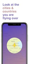
Aboard is the world’s first flight navigator to use on board of an aircraft. It works absolutely offline. Use Aboard and you will know: • where your flight is on a world map • passed and remaining time and distance • speed & altitude of your aircraft • what cities and countries you are flying over
  • Overview
  • Launches1
  • Reviews
  • Alternatives
  • Team
  • More
Company Info
smallapps.io/aboard
Aboard Info
Launched in 2018View 1 launch
Forum
p/aboard
  • Blog
  • •
  • Newsletter
  • •
  • Questions
  • •
  • Forums
  • •
  • Product Categories
  • •
  • Apps
  • •
  • About
  • •
  • FAQ
  • •
  • Terms
  • •
  • Privacy and Cookies
  • •
  • X.com
  • •
  • Facebook
  • •
  • Instagram
  • •
  • LinkedIn
  • •
  • YouTube
  • •
  • Advertise
© 2025 Product Hunt
SocialX
Basecamp
Basecamp — Famously straightforward project management from 37Signals
Famously straightforward project management from 37Signals
Promoted

Do you use Aboard?

Reviews
Helpful

You might also like

App in the Air 5.0
App in the Air 5.0
Flight Tracker. The best TripIt alternative yet
FlightStatus
FlightStatus
Your travel companion
Plane Finder
Plane Finder
Identify airplanes with iPhone
FlightTrack
FlightTrack
Track your flights and get quick updates on changes/delays
RouteHappy
RouteHappy
Flight-rating service for with details like WiFi and outlets
App in the Air
App in the Air
Fly smarter
View more
Review Aboard?Be the first to review Aboard
Aboard gallery image
Launch tags:
iOS•Productivity
Launch Team
Roman SilinEkaterina StrokinaOleg Borisov

What do you think? …

Nicolo S
Nicolo S
PumpMyGas by Optimist

PumpMyGas by Optimist

How does it work? Does it just estimate flight paths? 😀 Looks great!
Report
7yr ago
Vivek Sancheti
Vivek Sancheti
Pagedone

Pagedone

@coconidodev exactly. Does it just estimates? Or uses some real data?
Report
7yr ago
Oleg Borisov
Oleg Borisov
Aboard

Aboard

Maker
@coconidodev @evivz Hello guys! Of course it uses real data. We use GPS-data.
Report
7yr ago
Vivek Sancheti
Vivek Sancheti
Pagedone

Pagedone

@coconidodev @oleg_borisov aha thats great. Will give it a try for sure then.
Report
7yr ago
Alexey Krasnoslobodtsev
@coconidodev @evivz @oleg_borisov is it somehow connected with flightradar24?
Report
7yr ago
Oleg Borisov
Oleg Borisov
Aboard

Aboard

Maker
@coconidodev @evivz @xe0s it isn't. Do you have any ideas about that?
Report
7yr ago
Ghost Kitty
Ghost Kitty
Comment Deleted
Report
7yr ago
Roman Silin
Roman Silin
Fairsplit

Fairsplit

Maker
@stevenjames It’s an application for common people, not for pilots)
Report
7yr ago
Robert Magrino
Robert Magrino
Does the paid versIon gIve more detaIl? I can get the same information from the entertainment system. What I would like is a Google Earth type view so I can see detail. I want to know which national parks I’m flying over, mountain ranges, landmarks, US Route 66, etc. basically give me a 35000 foot view.
Report
7yr ago
Tom Bielecki
Tom Bielecki
@rmagrino This is exactly what I want in the air. I someday want to use AR to identify what is outside of my window. This shouldn't be tremendously difficult.
Report
7yr ago
Oleg Borisov
Oleg Borisov
Aboard

Aboard

Maker
@rmagrino Paid version gives you ability to watch the speed & altitude of an aircraft. Speaking of map detalization, we show objects on the map to a level of villages. So yes, you can watch national parks etc.
Report
7yr ago
Robert Magrino
Robert Magrino
@oleg_borisov great start, but it needs work. Maybe If you are flying from Seattle to Miami that you could download the detail for that flight.
Report
7yr ago
Oleg Borisov
Oleg Borisov
Aboard

Aboard

Maker
@rmagrino Yes, maybe we'll add more detailed map and ability to download it in future versions. Thanks.
Report
7yr ago